
Pulau Tiga national park
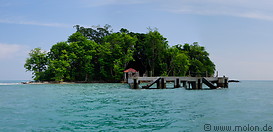
The Pulau Tiga Marine National Park is located 12km north of Kuala Penyu (Klias Peninsula) and consists of three islands. The biggest of them is Pulau Tiga and measures about 1km from northeast to southwest and 5km from northwest to southeast. The other two islands are very small. Pulau Kalampunian Besar is nothing more than a narrow strip of sand with some vegetation, extending for 1km from northwest to southeast. Pulau Kalampunian Damit, also known as Pulau Ubar or Snake Island is a small islet with some trees, where sea snakes come to mate and nest.
The islands are of volcanic origin and were formed in 1897, when an earthquake in the Philippines caused a volcanic eruption near Sabah.
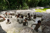
The Pulau Tiga Marine National Park was set up in 1978 and covers an area of 15864 ha. On the main Tiga island there is a resort and there is Accommodation of Sabah parks. The sea waters around Tiga island are not very clear, probably due to the proximity to the mainland. On Tiga island there are some mud volcanoes with mud pools, where visitors can take a bath in the mud.
The islands are of volcanic origin and were formed in 1897, when an earthquake in the Philippines caused a volcanic eruption near Sabah.
The Pulau Tiga Marine National Park was set up in 1978 and covers an area of 15864 ha. On the main Tiga island there is a resort and there is Accommodation of Sabah parks. The sea waters around Tiga island are not very clear, probably due to the proximity to the mainland. On Tiga island there are some mud volcanoes with mud pools, where visitors can take a bath in the mud.
|
|
|
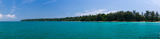
24 photos of Pulau Tiga, the biggest island of the Pulau Tiga marine national park
|
11 photos of the mud volcano on Pulau Tiga, a number of mud pools in the centre of the island
|
|
|
|
|
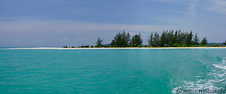
13 photos of Pulau Kalampunian Besar, a narrow strip of sand with some vegetation, northwest of Pulau Tiga
|
10 photos of Pulau Kalampunian Damit, a small islet northwest of Pulau Tiga, where sea snakes come to breed and nest
|
Gallery with all images
|
Page viewed 6380 times since 09.12.13
©Copyright Alfred Molon