
Alexandria
The city of Alexandria lies along Egypt's Mediterranean coast, 180km northwest of Cairo. The city extends over a narrow strip, extending for 20km along the coast and only 3km inland. It is the largest seaport of Egypt, through which 80% of Egypt's imports and exports pass.
Alexandria was founded in 331 BC by Alexander the Great and later became a very important city in the Roman empire and a major centre of the sciences. After the fall of the Roman empire it experienced a period of decline, which lasted until the arrival of Napoleon in 1798. In the 19th and the first half of the 20th centuries Alexandria boomed again, then entered into a phase of decline after the take over of Nasser in 1952.
Alexandria only has a few sights which may be of interest for tourists. The waterfront is in a very poor state, since it consists of an endless wall of concrete skyscrapers. The Corniche (i.e. the coastal road) is always congested with traffic and there are no traffic lights to help pedestrians cross the street.
|
|

|
|
|
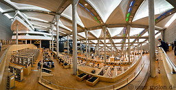
11 photos of the Bibliotheca Alexandrina in Alexandria, a major library and study centre
|
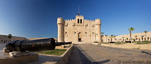
19 photos of Fort Qaitbey, a fortified citadel along the Mediterranean coast in Alexandria
|
8 photos of the Borg El Arab airport 40km southwest of Alexandria
|
Gallery with all images
|
Page viewed 10604 times since 07.04.12
©Copyright Alfred Molon